

J.D. Potié
PONTIAC July 16, 2019
On July 16, the Quebec government unveiled its revised map for the special intervention zone (ZIS) along with a number of construction regulations to put a hold on . . .
projects in flood zones until further notice.
After releasing a map largely deemed as exaggerated and inaccurate by community leaders all over the region earlier this month, the newest version of the ZIS was modified to represent a more accurate depiction of the territory affected by the 2017 and 2019 floods.
With the new delimitations, the government is banning construction and renovation of buildings destroyed by a flood in the ZIS, unless they meet the criteria for exception. The exception allows for damage assessment on properties where water had reached the ground floor, the foundations need to be replaced or where stabilization work is needed.
Victims from the 2019 floods may be eligible to register for the Ministry of Public Security’s Compensation and Assistance Program for Real and Imminent Disasters, which can offer up to $200,000 or 90 per cent of a home’s value in financial relief.
Residents whose property is evaluated as being less than 50 per cent destroyed, are invited to get in touch with their municipalities to get their situation examined.
A ZIS is a legal power exercised by the government to press the pause button on any construction in certain areas affected by natural disasters until they come up with an action plan on how to deal with them.
Not new to the province, they’d been put in effect on three occasions prior to this one. The first time was in Saguenay, the second in St-Jean-sur-Richelieu and the last two being for the 2017 and 2019 floods.
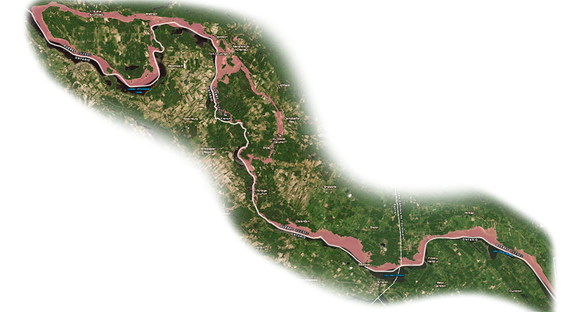
The ZIS consist of all properties within the 0-20-year watermark and all areas hit by the heavy floods of last spring and of two years past.

However, many local residents and community leaders believe that it still doesn’t represent the territory accurately.
According to Municipality of Pontiac Mayor Joanne Labadie, the biggest difference between this year’s ZIS compared to the one from two years prior is that it represents a much larger portion of the territory, which is likely because the 2019 floods were more severe than in 2017 and because they both occurred in such a short timeframe.
Labadie noted that each municipality is very different in its landscape and that the map still doesn’t fairly reflect the reality of the flood zones.
“What this map failed to do was to take into account our topography, specifically elevation,” she said. “We have areas in our municipality that have not seen water since the Ice Age. But, they’re in the map.”
Since the unveiling of the initial ZIS map around a month ago, municipal staff have been hard at work trying to remove certain properties and areas from the flood zone and have had some successes in doing so.
However, many more areas need to be taken off the map, including sections of Quyon, avenue des Plages and parts of chemin Cedarvale among others, Labadie said.
According to Labadie, the Municipality is working to provide the government with more accurate mapping that takes into account both elevation and areas actually reached by water and hope that it will be put into effect.
“We have the digital technology and the software technology to be able to do that,” she said. “We have all of the maps that show exactly where the water went and what the elevation of those properties are that will show that even in the worst case. And they’re very accurate, far more accurate than the ZIS map.”

Throughout the municipality, approximately 180 properties sit outside of the 100-year floodplain, were never flooded but are included in the ZIS.
The municipality has received over 70 e-mails so far regarding citizens living outside the floodplain wanting to be removed from the map and are continuing to get more, Labadie said.
After the floods of 2017, the municipality signed off on the demolition of 29 homes affected. This year, many more will be demolished, Labadie said.
Labadie noted that the government didn’t do the necessary consulting with municipalities to represent the flood zones fairly.
“Basically, they just went by satellite images,” she said. “They did it too quickly. They should have consulted the municipalities first who really understand the geography of the region better than some bureaucrats in Quebec City.”
In Alumettes Island, the town’s sole municipal inspector has been overwhelmed with residents demanding to be removed from the ZIS, according to Mayor Winston Sunstrum.
“We’ve been inundated with calls and people stopping in and wanting immediate responses and so on,” he said. “It’s been really crazy.”
So far, an undetermined large number of properties in the town are affected in some way by the ZIS, Sunstrum said.
Whether it’s people not in the flood zone worried that they are, those in the flood zone wanting to be taken out, or residents in the flood zone who are worried about their property’s value, plenty of question are being asked without many answers, Sunstrum said.
“We won’t know the answers for another month at least,” he said.
According to Sunstrum, the municipality has asked for an independent review of the floodplain and of dams in the province to get answers on how to alleviate flooding in the region going forward.
“People don’t have a lot of confidence in how the river is managed,” he said. “I think an independent review would maybe restore some confidence in the system. At some point, we need to find out exactly what happened and we need to plan for the future.”
For Sunstrum, one of most worrisome aspects about the ZIS as it stands is the effect that it may have on the town’s population and ultimately the money people pay to live there.
“Fewer people are going to have to share the tax burden, which will likely result in an increase for individuals.”
But the most imminent issue for the municipality remains solving the problems of each individual affected by the ZIS in a negative way, Sunstrum said.
Pontiac MNA André Fortin didn’t hold back when giving his thoughts on the new delimitations during a phone interview with The Equity on July 22.
“The map is erroneous,” he said. “The map was made in a rush by the government of the Coalition Avenir du Quebec.”
The government held a public consultation in Campbell’s Bay on July 4. The session was intended for locals to give their thoughts on the ZIS, how it affects them and what changes they’d like to see.
However, Fortin has dubbed the government’s response as “incompetent” and quite disappointing and ignorant towards the difficulties affected residents are left to face.
“They promised to adjust the map, that their errors would all be fixed,” he said. “That everyone who wasn’t flooded either in 2017 or 2019 would be removed from this map and that hasn’t been the case.”
“In all evidence, the government hasn’t been able to adjust the map correctly following the consultation,” he added. “It’s a little insensitive towards the reality lived by all these people to say that people have the possibility of expressing themselves. The government didn’t listen to everyone express themselves.”
Although the new delimitations don’t paint as broad a stroke as the initial one, it still leaves hundreds of Pontiac residents in a precarious position, many of whom have never been flooded, Fortin said.
“It’s going to have a significant effect on the value of their residence,” he said. “There’s also an impact on the value of their insurance.”
According to Fortin, removing all residences that weren’t physically affected or damaged by the floods that find themselves in the ZIS is imperative.
For Fortin, the government assigning the duty of consulting residents affected to rural municipalities instead of managing it themselves is an unrealistic expectation.
“What the government indicated is that it’s putting the bu rden on the municipalities,” he said. “Instead of taking care of their own responsibilities.”
As most municipal offices in the Pontiac only have a single part-time employee taking care of business, he noted that many municipalities in the region lack the necessary staff to deal with every situation with the respect and diligence they require, on top of the numerous issues they had already been dealing with.
“They have to deal with taking in the residents demands, analyze them, decide which ones are legitimate, to be the one who say yes or no to citizens and then send those recommendations to Quebec – all that in a period of a few weeks” he said.
“In certain places where they have resources like Gatineau, it can always work out,” he added. “But in our small municipalities it’s a lot to ask to municipalities that already faced the difficulties of flooding.”
With hundreds of residents in the lurch not knowing how to move forward with construction on their properties, Fortin urged the importance of the government doing everything it can to help out every single individual affected by the ZIS.
“Right up until the very last residence, it’s important that the work gets done correctly,” he said. “We’re talking about life investments for numerous residents. That’s why it’s important that the government pays attention to every detail instead of doing things too quickly like they did.”
The ZIS delimitation could potentially have substantially negative effects on the local population, one being that it will prevent growth in population and infrastructure in various parts of the region that have never been hit by a single drop of river water.
But most importantly for residents, it’s going to take a serious toll on the value of many homes in the Pontiac, Fortin said.
“A lot of people are worried and with reason,” he said. “They expect the government to correct their mistake.”
To report any inaccuracies to the new flood map, people are asked to contact their municipalities, who will be able to submit their concerns to the Ministry of Public Security up until August 19.
To consult the map, residents are invited to check out the new delimitations by entering the following link : https://www.cehq.gouv.qc.ca/zones-inond/ZIS-20190715/index.html.