
*This story was last updated on Apr. 20 at 5:15 p.m..
The Ottawa River Planning Board is still forecasting another day of rising water levels after a week of rain and warm temperature caused significant snowmelt and spring runoff across the Ottawa River watershed.
On Apr. 20, the board predicted levels would peak on Tuesday, Apr. 21, with peaks of 113.15 m in Pembroke, 108.75 m in Lac Coulonge, and 75.85 m in Chats Lake (Quyon), and then stabilize and slowly decrease over the second half of the week.
These are lower than the 2023 peak levels in Pembroke by 10 cm, equal to that year’s peak levels in Lac Coulonge, and 5 cm lower in Chats Lake.
Historical high levels for Pontiac’s stretch of the Ottawa occurred in mid-May of 2019, when they hit 109.17 m in Lac Coulonge and 76.28 m at Chats Lake.
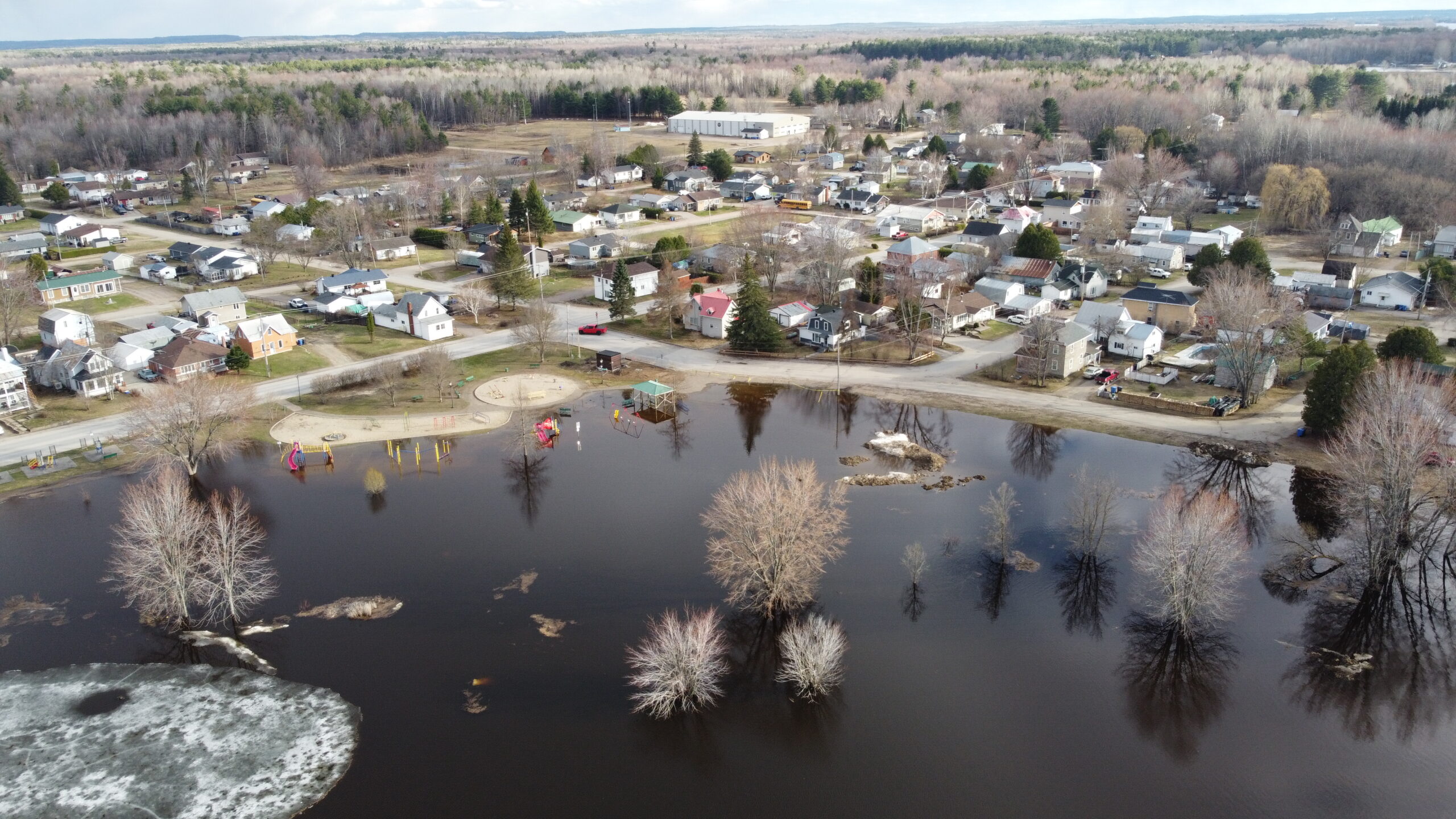
“Major flood levels have been exceeded in flood prone areas from Lake Coulonge to Lake Deschenes, and are expected to be reached or exceeded today from Gatineau-Hull to Carillon,” the planning board’s Monday afternoon forecast stated. The major flood level is defined as the level at which one or several streets are beginning to flood, with several houses/buildings or neighbourhoods being affected.
In the Municipality of Fort-Coulonge on Monday morning, the Ottawa River was already at 108.60 m, a day ahead of when the planning board had predicted this level. The Coulonge river was at 110.33 m, with a flow of 736 m³/s.
“We’ve found that the forecasts are not so accurate,” said mayor Pierre Cyr. “It’s going to go above 108.6 easily, we’re already there. It’s probably going to be more like 108.8 m. It’s [rising] a centimeter an hour right now. [ . . . ] We’re hoping it’s going to stop increasing but there’s no way of knowing for sure. If the water goes to 109 m, we won’t have time to react if it goes that high.”
On Sunday evening, the municipality issued a state of emergency to expedite its ability to respond to the flood.
“We need extra people and a lot of materials, and financially while you’re under the umbrella of the emergency, it will be partly reimbursed,” Cyr explained, adding that operating within a state of emergency enables the municipality to make quick decisions without having to go to council for approval.
“We have full power, we don’t need to ask questions to the council, we have the go-ahead to deal with the emergency.”
Cyr said his main concerns are preventing the flood waters from entering the town’s sewage system, and reducing strain on the water filtration system.
“If the water passes over the roads [ . . . ] it will make our waste and sewage system useless. Then we would have to evacuate the people and it would cause a lot of problems in the basement, so that’s our main concern,” Cyr said, noting the municipality is building several sand dikes in key locations to prevent water from entering its sewage system.
“And the other concern is the water treatment for potable water. Right now it’s having a hard time pumping the water from the river, not because there’s not enough but because there’s a lot of debris and fine particles in the water that impacts the capacity of filtration for it to be potable.”
For this reason, Fort-Coulonge and Mansfield municipalities are asking residents to reduce consumption of drinking water until the end of the flood, to ease pressure on the towns’ water treatment plants.
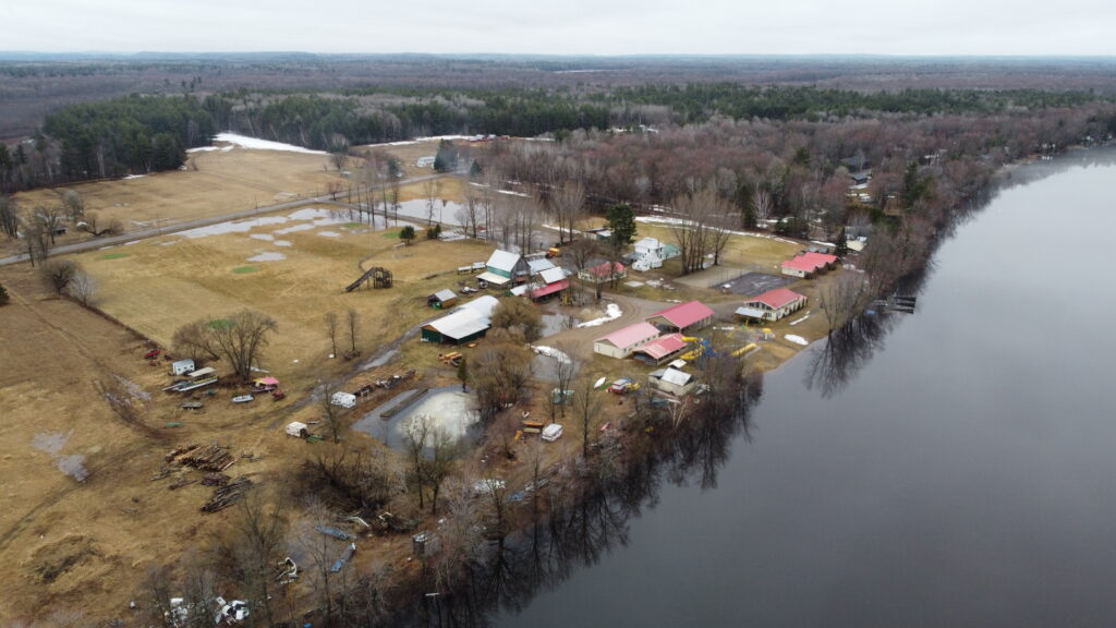
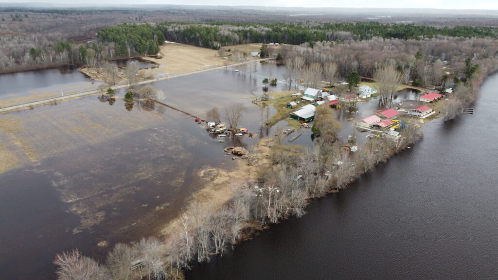
Over the weekend, the Municipality of Mansfield-et-Pontefract evacuated some 70 residents and cottagers from streets that had been flooded.
“We invite them to leave the sectors when we close down the streets because if there’s an emergency, it’s going to take longer for [emergency responders] to get there. And if they need a place to live, well we can fix that, temporarily,” said mayor Sandra Armstrong.
The people who decide not to leave are asked to sign a waiver confirming they are choosing to stay put despite the flooded roads.
Armstrong emphasized that residents should not be driving through flooded roads as the risk of getting stuck is high.
“Yesterday there were three or four cars that got stuck and our firefighters had to evacuate people from the cars, I think it was 12 or 13, so two of our fire crew had to go up there and do that, so that’s a really big problem.”
Armstrong said the municipality will be closing a few more streets today (Apr. 20), but that it is so far holding off from declaring a state of emergency.
“Right now we have our emergency plan, we’re using that, and we’re still in our spending budget, so I think right now at 10:34 a.m. we’re still good with our plan.”
The planning board forecasts flood levels will begin to recede on Wednesday, Apr. 22 thanks to cooler temperatures and dry weather.
Road closures
The following roads have significant flooding, with some closed to traffic altogether. Please note, this list is likely incomplete. If you know of roads that are closed please be in touch with editor@theequity.ca:
Mansfield-et-Pontefract:
- Chemin de la Chute
- Chemin des Rapides
- Chemin de la Passe
- Chemin Thomas-Levebvre
- Rue Neault
- Rue l’Écuyer
- Rue Mathias
- Rue Laporte
- Rue Léonard
- Chemin du Grand-Marais
- Rue Felix
- Rue Bélec
- Rue Mousseau
- Rue Boisvert
- Chemin Esprit
- The Félix-Gabriel-Marchand Bridge (closed by MTQ to protect it)
Fort-Coulonge:
- Rue Bord de l’Eau
Thorne:
- Chemin Bryson between chemin Brouse and chemin Anderson
- Thorne Lake Road is also closed. If you need to travel, please use Wesley or 12th Line as alternate routes.
- Mountain Road is practically impassable due to a cleanup operation underway involving heavy machinery
- The 366 between Ladysmith and Lac-des-Loups had significant flooding late last week and may still be affected
Waltham:
- Black River Road is now closed to traffic as of Trout Lake Road as there is about four inches of water on the road between Kilometre 12 and Kilometer 15. In some places the water is nine inches deep.
- Chemin du Traversier was closed Saturday
Campbell’s Bay:
- A portion of chemin River – the municipality has restricted access to local traffic only on rue Second to chemin River, beginning at the intersection of rue McLellan.
Otter Lake:
- The bridge on chemin Polish Hills bridge (closed by the MTQ)
- The bridge on chemin Blaskie
Clarendon:
- chemin River in Sand Bay
L’Isle-aux-Allumettes:
- chemin M – completely closed
- chemin F – completely closed
- chemin Murphy’s Point – completely closed
- chemin O’Brien’s Bay – west side closed
- chemin Owls Landing – east side closed
- chemin Maxime – partially closed
- chemin Violet-Robert – partially closed
*Ce reportage a été mis à jour le 20 avril à 17 h 15.
La Commission de planification de la rivière des Outaouais prévoit toujours une nouvelle journée de hausse des niveaux d’eau après une semaine de pluie et de températures chaudes qui ont provoqué une importante fonte des neiges et un ruissellement printanier dans tout le bassin versant de la rivière des Outaouais.
Le 20 avril, la Commission a prédit que les niveaux culmineraient le mardi 21 avril, avec des pointes de 113,15 m à Pembroke, 108,75 m au lac Coulonge et 75,85 m au lac des Chats (Quyon), avant de se stabiliser et de diminuer lentement au cours de la deuxième moitié de la semaine.
Ces niveaux sont inférieurs de 10 cm aux niveaux de pointe de 2023 à Pembroke, égaux aux niveaux de pointe de cette année-là au lac Coulonge, et inférieurs de 5 cm au lac des Chats.
Les niveaux historiques les plus élevés pour le tronçon de l’Outaouais dans le Pontiac ont été atteints à la mi-mai 2019, lorsqu’ils ont atteint 109,17 m au lac Coulonge et 76,28 m au lac des Chats.
« Les niveaux de crue majeurs ont été dépassés dans les zones inondables du lac Coulonge au lac Deschênes, et devraient être atteints ou dépassés aujourd’hui de Gatineau-Hull à Carillon », a déclaré la Commission de planification dans ses prévisions de lundi après-midi. Le niveau de crue majeur est défini comme le niveau auquel une ou plusieurs rues commencent à être inondées, avec plusieurs maisons/bâtiments ou quartiers touchés.
Lundi matin, dans la Municipalité de Fort-Coulonge, la rivière des Outaouais était déjà à 108,60 m, un jour plus tôt que ce que la Commission de planification avait prévu pour ce niveau. La rivière Coulonge était à 110,33 m, avec un débit de 736 m³/s.
« Nous avons constaté que les prévisions ne sont pas très précises », a déclaré le maire Pierre Cyr. « Il va facilement dépasser 108,6, nous y sommes déjà. Ce sera probablement plus comme 108,8 m. Ça [monte] d’un centimètre l’heure en ce moment. [ . . . ] Nous espérons que ça va arrêter d’augmenter, mais il n’y a aucun moyen de le savoir avec certitude. Si l’eau atteint 109 m, nous n’aurons pas le temps de réagir si elle monte aussi haut. »
Dimanche soir, la municipalité a déclaré l’état d’urgence afin d’accélérer sa capacité à intervenir face à la crue.
« Nous avons besoin de personnel supplémentaire et de beaucoup de matériaux, et financièrement, tant que vous êtes sous le régime de l’urgence, ce sera partiellement remboursé », a expliqué Cyr, ajoutant que l’opération en état d’urgence permet à la municipalité de prendre des décisions rapides sans avoir à obtenir l’approbation du conseil.
« Nous avons tous les pouvoirs, nous n’avons pas besoin de poser des questions au conseil, nous avons le feu vert pour gérer l’urgence. »
Cyr a déclaré que ses principales préoccupations sont d’empêcher les eaux de crue de pénétrer dans le système d’égouts de la ville et de réduire la pression sur le système de filtration de l’eau.
« Si l’eau passe par-dessus les routes [ . . . ] cela rendra notre système d’égouts et d’assainissement inutile. Nous devrions alors évacuer les gens et cela causerait beaucoup de problèmes dans les sous-sols, c’est donc notre principale préoccupation », a déclaré Cyr, notant que la municipalité construit plusieurs digues de sable à des endroits clés pour empêcher l’eau de pénétrer dans son système d’égouts.
« Et l’autre préoccupation est le traitement de l’eau potable. En ce moment, il a du mal à pomper l’eau de la rivière, non pas parce qu’il n’y en a pas assez, mais parce qu’il y a beaucoup de débris et de fines particules dans l’eau, ce qui a un impact sur la capacité de filtration pour qu’elle soit potable. »
Pour cette raison, les municipalités de Fort-Coulonge et Mansfield demandent aux résidents de réduire leur consommation d’eau potable jusqu’à la fin de la crue afin de soulager la pression sur les usines de traitement d’eau des villes.
Au cours du week-end, la Municipalité de Mansfield-et-Pontefract a évacué quelque 70 résidents et propriétaires de chalets des rues qui avaient été inondées.
« Nous les invitons à quitter les secteurs lorsque nous fermons les rues, car en cas d’urgence, il faudra plus de temps aux [intervenants d’urgence] pour y arriver. Et s’ils ont besoin d’un endroit où vivre, eh bien, nous pouvons régler cela temporairement », a déclaré la mairesse Sandra Armstrong.
Les personnes qui décident de ne pas partir sont invitées à signer une décharge confirmant qu’elles choisissent de rester malgré les routes inondées.
Mme Armstrong a souligné que les résidents ne devraient pas rouler sur les routes inondées, car le risque de rester coincé est élevé.
« Hier, trois ou quatre voitures sont restées coincées et nos pompiers ont dû évacuer des personnes des voitures, je crois qu’il y en avait 12 ou 13, donc deux de nos équipes de pompiers ont dû y aller et faire ça, c’est donc un très gros problème. »
Mme Armstrong a déclaré que la municipalité fermerait quelques rues de plus aujourd’hui (20 avril), mais qu’elle s’abstient pour l’instant de déclarer l’état d’urgence.
« En ce moment, nous avons notre plan d’urgence, nous l’utilisons, et nous sommes toujours dans notre budget de dépenses, donc je pense qu’en ce moment, à 10 h 34, notre plan est toujours bon. »
La Commission de planification prévoit que les niveaux d’eau commenceront à baisser le mercredi 22 avril grâce à des températures plus fraîches et un temps sec.
Fermetures de routes
Les routes suivantes sont considérablement inondées, certaines étant complètement fermées à la circulation. Veuillez noter que cette liste est probablement incomplète. Si vous connaissez des routes fermées, veuillez contacter editor@theequity.ca :
Mansfield-et-Pontefract :
- Chemin de la Chute
- Chemin des Rapides
- Chemin de la Passe
- Chemin Thomas-Levebvre
- Rue Neault
- Rue l’Écuyer
- Rue Mathias
- Rue Laporte
- Rue Léonard
- Chemin du Grand-Marais
- Rue Felix
- Rue Bélec
- Rue Mousseau
- Rue Boisvert
- Chemin Esprit
- Le pont Félix-Gabriel-Marchand (fermé par le MTQ pour le protéger)
Fort-Coulonge :
- Rue Bord de l’Eau
Thorne :
- Chemin Bryson entre le chemin Brouse et le chemin Anderson
- Le chemin Thorne Lake est également fermé. Si vous devez voyager, veuillez utiliser Wesley ou la 12e Ligne comme itinéraires alternatifs.
- Le chemin Mountain est pratiquement impraticable en raison d’une opération de nettoyage en cours impliquant de la machinerie lourde
- La route 366 entre Ladysmith et Lac-des-Loups a été considérablement inondée en fin de semaine dernière et pourrait toujours être affectée
Waltham :
- Le chemin Black River est maintenant fermé à la circulation à partir du chemin Trout Lake car il y a environ quatre pouces d’eau sur la route entre les kilomètres 12 et 15. À certains endroits, l’eau atteint neuf pouces de profondeur.
- Le chemin du Traversier a été fermé samedi
Campbell’s Bay :
- Une partie du chemin River – la municipalité a restreint l’accès à la circulation locale uniquement sur la rue Second jusqu’au chemin River, à partir de l’intersection de la rue McLellan.
Otter Lake :
- Le pont sur le chemin Polish Hills (fermé par le MTQ)
- Le pont sur le chemin Blaskie
Clarendon :
- Chemin River à Sand Bay
L’Isle-aux-Allumettes :
- Chemin M – complètement fermé
- Chemin F – complètement fermé
- Chemin Murphy’s Point – complètement fermé
- Chemin O’Brien’s Bay – côté ouest fermé
- Chemin Owls Landing – côté est fermé
- Chemin Maxime – partiellement fermé
- Chemin Violet-Robert – partiellement fermé